Let’s encourage the Town of Colonie to create a safe way for pedestrians and bicyclists to access the Mohawk Hudson Bike Trail from the county-wide bike trail that dead-ends on busy Rt 7 / Troy-Schenectady Rd.
In the works for more than 20 years, all that's left to accomplish this is a connection from Rt 7 near Keeler's Campus/Cumberland Farms down to River Road. This would be a win-win for everyone, a boon to local families, a benefit to nearby businesses, and a major recreational enhancement for our town.
Learn the facts here!

Help make the bike path connector a reality!
Contact Supervisor Peter Crummey
518-783-2728 or Colonietownsupervisor@colonie.org, and Planning Board Chair Steven Heider
c/o SEAN M. MAGUIRE, Director of Planning and Economic Development, at maguires@colonie.org
Let them know it’s time to do this.
Do the Right Thing, Colonie!
Together, the Albany Bicycle Coalition, Parks & Trails NY, Friends of the Mohawk Hudson Bike Trail, Vly/Denison Birchwood Road Neighborhoods, SAVE Colonie and several River Road neighbors recently urged the Town to create a safe connection. Read their letter to Supervisor Peter Crummey and Sean Maguire, Director of Planning and Economic Development. Parks & Trails New York also wrote to Supervisor Crummey and submitted written comments.
River Road Neighbor David Pratt testified eloquently and in detail at the 1/25 Planning Board meeting about the many economic and recreational benefits of the connector. His words and those of the larger community were ignored.
UPDATE: Times Union article on the bike path connection, Feb 12, 2022
Timeline of the Bike Path Connection
In 2000, a connection between the bike trails throughout Colonie and the Mohawk Hudson Bike-Hike Trail system was attempted. In 2001, approximately $200,000 of taxpayer money was spent to build a bridge over Watervliet-Shaker Road to facilitate this connection. All that’s left to complete is a short stretch from Route 7 down to River Road and the Mohawk Hudson Bike Trail. (See Map)
The Town of Colonie’s 2005 Comprehensive Plan cites the importance of multi-use connections between neighborhoods as integral to the recreational quality of our Town.
The December 2005 Route 2 Route 7 Corridor Study identifies the need for a “connection [from] the British American Boulevard multi use path to the Mohawk Hudson Bike-Hike Path.”
The Town’s draft Pathways Plan (2008) called for multi-use paths “to address alternative modes of transportation.”
The CDTC Bike Path Study & Recommendations, of August 2018, CDTC BikePath Study cited the missing connection from Route 7 down to River Road as essential to complete this county-wide trail system.
Colonie’s 2019 Comp Plan Update highlighted the need for non-vehicle transportation within the Town, including access to trail systems and preserved spaces. It ordered the Planning and Economic Development Department to further explore resources for non-motor vehicle transportation, and to improve access to trail systems.


Niskayuna gets it!
Just west of Colonie, in 2017, the Town of Niskayuna created a bike path connection through the proposed Flower Hill development between Route 7 and River Road. Capital District Transportation Committee (CDTC) provided $229,000 grant funding (80% of the cost) to construct the paved pathway, and a traffic light was installed. “The project is designed to improve the pedestrian/cycling environment by better connecting hundreds of households in the eastern end of Niskayuna to the Mohawk-Hudson Bike Trail.”
In Colonie, Opportunities have been missed!
In approving the development of Cumberland Farms on Route 7, in 2016, the Colonie Planning Board sought to create the bike path connection by requiring, as a condition of approval, that Cumberland Farms grant an easement through its property. Attorneys for Cumberland Farms even agreed to easement language for inclusion in the conveyance. Unaccountably, no such easement was ever included or filed. The development has been completed without an easement. Opportunity lost.
colonie’s last opportunity
Several proposals have recently come before the Town to develop sites along the north side of Route 7, the last sites appropriate for bike/pedestrian access to the Mohawk-Hudson Bike Hike Trail. We urge the town to seize this last opportunity to enhance our community’s recreational assets and safety by finally making this connection a reality.
Here are three great options:
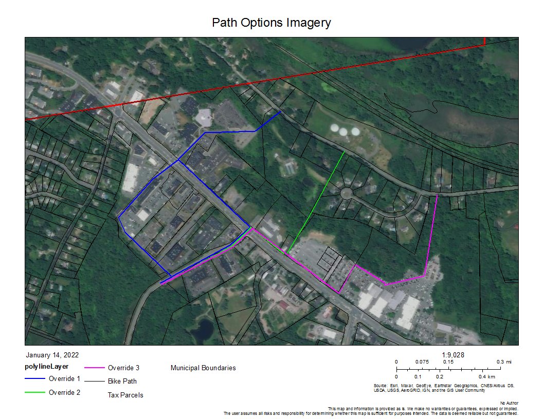
Keeler’s Expansion: The current Keeler’s dealership expansion proposal originally included a connection from Route 7 through the dealership to River Road, for test drives as well as a pedestrian-bicycle route. You can read the narrative from that original proposal here. Site plans can be viewed here and here.
When a few wealthy neighbors complained about loss of privacy and outsiders in their backyards, and hired a lawyer, Keeler withdrew the connection proposal. While adding more auto traffic to River Road would not be beneficial to the neighborhood, a bike path connection would certainly provide many benefits to our community as a whole. [PINK line on map below]Existing National Grid/Town of Colonie Right of Way: A utility right of way currently exists along the boundary between Orlop’s Farm (4070 River Rd,) and a few houses on Northview Dr., down to River Road. The Town owns a lot on River Road at the bottom of this easement, directly across from the bike path. This would make an easy pedestrian/bicycle connection. [GREEN line on map below]
Riverhill: Further development of this site will come within a few hundred yards of River Road, offering a short and not very steep way to connect the parking lot of this development on Route 7 to River Road. Grading will be needed to deal with stormwater, providing an opportunity to create the connection. [BLUE line on map below]